This is a great place to run. There’s a local coffee shop with Wifi, decent coffee, and excellent donuts, a small but reasonably priced grocery store, lots of hiking/mountaineering stores, and tons of food options in town (WAY more than you’d expect from a town the size of Leadville). Expect rattlesnakes in the valley and bears in the mountains.
The Whitney Trail to Lone Pine Lake: Mountain/Trail Running 5.5mi RT, 1700ft
You can take the paved road all the way to the Mt. Whitney Trailhead. The trail is very switchbacked and low grade, so it’s very runnable, and you can go all the way to Lone Pine lake and back without needing a permit. There’s even a store at the TH if you forgot snacks or want a post-run Coke.
If you do have a lottery permit, or if you’ve managed to snag a last minute one due to a cancellation (if you go to recreation.gov and search Mt. Whitney, then select day use or backpacking, you’ll be able to see if there are any available permits due to cancellations), you can take the Whitney Trail as high as you like, maybe even up to the summit. The trail was buried in snow when I did it, but I am to understand that the whole thing is quite runnable in the summer months, and you’ll secure 6,300ft or so from the TH. Dogs are allowed all the way to Trail Crest, the rest of the route is in Sequoia National Park. I’ve heard folks have taken their dogs to the summit, but this area is heavily patrolled and I wouldn’t want to risk the fine, or getting kicked out.
Whitney Portal National Recreation Trail: Mountain/Trail Running 8mi RT, 2,200ft
My favorite run here was the combination of this trail, then adding the above Whitney trail to Lone Pine Lake. You can drive or ride your bike to the Lone Pine campground, which is just under the Portal road’s giant switchback, there’s day use parking, bathrooms, and water available here. From the TH to the Mt. Whitney TH is 4 miles and about 2,200 feet. The first 3 miles or so aren’t very heavily trafficked and have stunning views. The last mile winds through the campgrounds. Dogs are fine.

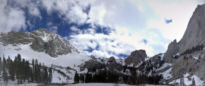
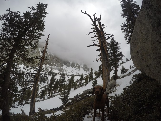
Meysan Lakes Trail: Mountain Running 10.8mi RT, 3,700ft [if you go all the way to Meysan Lake]
This is another one that you can do on its own or link up to the Whitney Portal NRT. The front end of this trail is also a heavily switchbacked, non technical trail so it’s easy to run. There was a ton of snow here in late May still, but like the Whitney Trail, it’ll clear up by mid summer. The last couple miles can be tricky to find, especially if there’s snow, as the trail gets grown over and isn’t well maintained so adventure at your will.
If you’ve taken the Portal NRT trail up, you’ll make a left at the first campground road intersection where there’s a sign for Meysan Lakes and follow the signs through the campground to the actual trail. Dogs are fine.
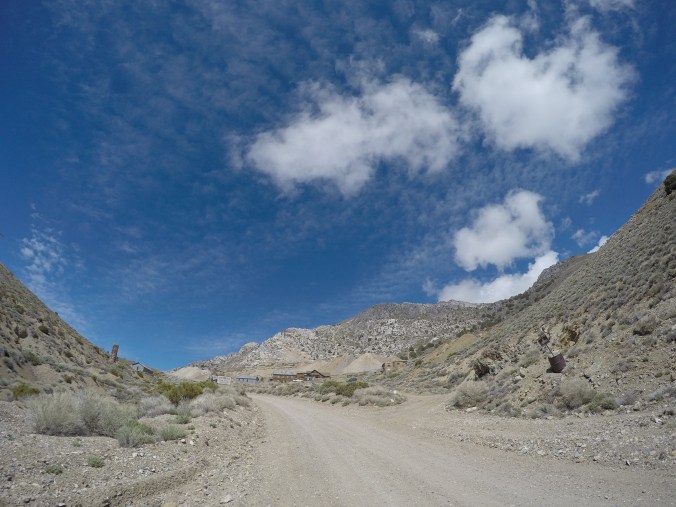
Cerro Gordo Mine: Mountain Running/MTB 15mi RT, 4,600ft
This is a 13 mile drive from Lone Pine to Keeling, but I definitely found it to be worth it. Since it climbs almost 5,000 feet in just over 7 miles and is well maintained, you get excellent climbing but at a low enough grade that it’s very runnable and it was snow free much earlier than the Sierras. Be sure to read the historical sign when you park at the beginning of the road, and there’s a ghost town up top if you make it there (although some folks bought it in 2018 and have put up rather aggressive no trespassing signs so be careful about that). Unfortunately, this is a also a well used road for ATVers, so I don’t highly recommend going on a weekend (which I did, and it was still fine, but dusty and noisy).
Mountain bikers with legs of steel could totally bike this road, or as much of it as they want to. Dogs are fine, but because of the traffic you’ll want them on a leash and note that there’s no water on route. Once you drive to Keeling, on the other side of “town” the Cerro Gordo rd will be your first left and you can park anywhere you’d like.
https://www.strava.com/activities/2400364216
Mobius Arch & Alabama Hills: Trail Running/MTB .5 miles to infinity
The Alabama Hills are comprised of a vast network of dirt roads, both maintained and unmaintained, with tons of interesting rock formations that you could climb or boulder (Goal Zero was here shooting their athletes climbing the shark’s fin, which was like 1000 feet from my campsite), and one trailhead, which is Mobius Arch. The Mobius Arch trail itself is a .5 mile rolling, super fun loop with the Arch and other cool rock formations, but there’s also an unsigned mountain bike trail that branches off of it to the left that goes on for miles (I went out four miles and could still see it going on and on in the distance). Combined with the network of Jeep roads that don’t have that much traffic, there are vast possibilities here to rack up miles on foot or bike, just without much gain to speak of. Dogs are fine, but there’s no water.

Horseshoe Meadows Rd: Road Biking/Road Running 46mi RT from Lone Pine, 39mi RT from Whitney Portal Rd/Horseshoe Meadows Rd JCT, less if you drive HM rd a bit and park in any of the pullouts. From Lone Pine, you’d climb a little over 6,000ft.
I was heartbroken to find out this road was paved, but on the flip slide, road runners and cyclists will be stoked for the opportunity to ride 10 paved miles with 5,000ft of gain (that’s if you parked in one of the pullouts just before the climbing starts, if you rode Horseshoe Meadows road in its entirety from the Whitney Portal Road or even from Lone Pine, you could have a big mileage day). At the top of this road are some (paid) camping options and the Cottonwood Pass Trailhead.
Cottonwood Pass: Mountainish Trail Running 7mi RT, 1,200ft
You’ve already driven (or ridden your bike) a lot of the gain to get here, so there’s not a ton more to do but you are at altitude in mountain conditions, and there are vast options for linking up to do some bushwacking, climb a mountain (like Mt. Langley, route directions here https://www.summitpost.org/mount-langley/150246), or join up with the PCT.
In the height of the summer months, you need to stop at the Ranger’s office in Lone Pine and pick up a free permit, as there is a daily quota in place, even for day use. As you do pretty much everywhere in the SIerras, you also need a permit to backpack up here (there’s also a USFS campground), if you were inclined. Dogs are fine, but if you’re linking up, know that dogs aren’t allowed in the National Parks.
The Whitney Portal Road Itself: Road Biking/Road Running 13.5mi and 4,600ft one way from Lone Pine, less starting in Alabama Hills
Is a truly excellent bike ride from Alabama Hills or Lone Pine. I ran it a couple times to the Lone Pine Campground to meet up with the Portal NRT (approximately 5 miles and 1,500ft depending on where you’re starting in AH), which was fine because it’s not that heavily trafficked, but pavement is pavement. I wouldn’t run it above the Lone Pine Campground because it gets narrow at the switchbacks and all the cars driving it are overheating their brakes so it reeks, and why would you when you have the opportunity to go up the trail instead? This downhill on a bike is the most perfect downhill grade of a paved road, plus it’s been recently repaved.
The East Side: Scrambling/Bushwacking
There are [often overlooked] mountains to the east of Lone Pine. While they don’t have any good developed trails, there are a bunch of abandoned, unmaintained mining roads that you can find and mix with some off trailing and scrambling if you’re feeling intrepid and want to do a little exploring. I took the Long John Canyon abandoned mining road up till it ended, and found a delightful cairned social trail above the Beveridge mine ghost town, and also scrambled up a random ridge. Chances are you won’t see any people at all, and you have pretty much unlimited opportunity for elevation gain if you don’t mind bushwacking. In the late summer, there won’t be water available anymore.


