A friend had graciously volunteered to drop me off and pick me up for some one-way linkups, so we set off from Leadville reasonably early and headed down to BV to start at Cottonwood Creek. The plan was Columbia to Harvard to Pine Creek to Oxford/Belford then down to Missouri Gulch, where we would camp. I thought this would take 8 hours, 12 if I got into trouble. It was forecasted to thunderstorm.
The morning was beautiful, I love the basin of Harvard and Columbia, the wildflowers were blooming, CFI was out working on the new and improved Columbia standard route. There were an extraordinary amount of Alpine Spiders out, and especially some really big, wicked looking ones. I made a mental note to look up whether there are any poisonous spiders living in the talus (since that episode on the Sawtooth, I am no longer irrationally afraid of spiders, but I’d still like to know if they can kill me). (If you’re wondering, my research didn’t uncover much. According to the internets, black widows, brown recluses, and “hobo” spiders are the only poisonous spiders in CO that are a threat to humans. While the big black ones I saw in the talus were horrific, they weren’t black widows, so I guess it’s safe?)
As we neared the summit of Columbia, I started thinking I saw storm clouds coming FROM THE EAST. Which is impossible, right? I kept an eye on them, carried on, but as I descended the summit onto the shitty crazy gnarly ridge, it was impossible to ignore them and I began the bail into the even shittier, crazier, talus field, all the way into a lush, green valley full of willows to the NE of the ridge. By now, the sky was blanketed in storm clouds, and it was sprinkling, but not storming yet. I began a very long ascent towards the summit of Harvard, thinking that along the way I’d find a crest to cross over down to Pine Creek, without having to summit Harvard in a storm. The North side of Harvard is very cliffy, and of course I couldn’t find a safe place to descend, especially since I had Luna with me. I could see the beautiful tundra-covered North arm that is the Nolan’s route, but the further up we went the more obvious it became that there was no way to get to it besides crossing directly over that rocky summit. As we approached it, I almost slowed down, trying to make the call. Up until now, we weren’t very exposed, but the final talus climb to the precarious summit would leave us extremely exposed to lightning for just a couple minutes. If I did it fast, would it be okay? Then the thunder started. There’s something about thunderstorms above treeline that make you feel like the mountains under your feet and the sky are about to break apart. We ran for our lives, bailing all the way back to the willow basin we had come from. I couldn’t think of another safe solution, so we began to descend East, hoping to come across the Colorado Trail.

lunchtime
At first, this was actually kind of a nice time. I sat down with Lu right around treeline and enjoying the epically beautiful, quiet, isolated valley while having some lunch. It rained off and on, but didn’t pour. Below treeline, things got nasty quickly. The rain picked up, and so did the piles of dead trees making a crazy tangled maze that it was impossible to climb over or under, so we had to wedge ourselves between trees and climb through. I was quite certain I’d come across bears, and spent the whole time yelling, and I also figured I couldn’t escape this without a host of ticks. There were freezing water crossings, more and more tree tangles, and it took hours to make it what had to be only 4-6 miles. When we found the Colorado trail, I thought I might burst into tears, but resisted, because I still had a long, long way to go and losing it is the perfect way to sap your limited energy.
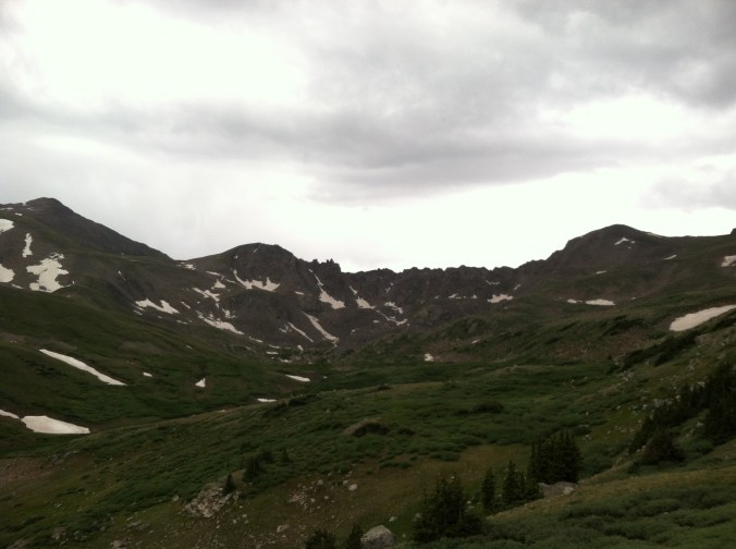
looking back on the ridge we bailed from, NE of Columbia
Maybe 15 minutes after gaining the trail, I saw a person! I asked her if she happened to know how far it was to Clear Creek and county road 390, and she said at least 11 miles. Which might have been disheartening, as that would make about 17 miles to get to my friend at Missouri Gulch, but 17 miles was reasonable on easy trail and road, and it was around 3pm so I figured I could make it before dark. The sky started to clear, and I jogged pretty contentedly. Crossing Pine Creek, I considered what it would take to off trail to Oxford from there, and finish my original route. Then, a trail junction. To ELKHEAD PASS. I took it, and up into the bowels of Pine Creek we went. It’s actually a beautiful area, if not a little creepy and very isolated. There are a ton of fairly intact mining buildings, with windows and padlocked doors. As we approached the southern slopes of Oxford, the thunderstorms rolled in again, so we continued on the trail to Elkhead Pass. I kept thinking we were going too far, that it didn’t make much sense. But as the sun began to set, I didn’t feel quite up to off trail route finding in a place that was unfamiliar, and I wished I had just ascended Oxford because at least I’d know where I was. After miles of going southwest, we suddenly wrapped around and headed North, and I understood that the trail had taken us several miles out of the way, only to bring us back around up through a valley we would ascend NE to the pass. It was one of the most beautiful basins I had ever seen. My knees had just about had it, the bail off the Columbia ridge had destroyed them and each subsequent mile was taxing too much. My nervous system was fried. I had been hoping and hoping that I could just make it back before dark, but darkness was coming too fast and I was moving too slow, and still had so many miles to go.
Gaining Elkhead Pass was another moment that I wanted to burst into tears. What a relief, after all the off trail, all the route finding and wondering, the bailing from storms, that I was on a trail that I knew. The thunderstorms raged over the mountains around me as the last bits of light dissipated. I got out my headlamp, the batteries needed replaced and I happened to have packed new batteries, but I couldn’t see well enough to change them. I descended as fast as I could, it still probably took over an hour from Elkhead Pass to Missouri Gulch parking lot as I arrived about 10pm. There I burst into tears, finally safe and sound. 35 miles, 11k gain, 15 hours.
The aftermath of that day has made me question what I’m doing with my life. I don’t ever want a day like that again. I didn’t even want to continue to pursue Nolan’s, as it will inevitably be a lot of the same isolation, loneliness, miserable off trail, painful gully descents that defy you to break all your bones. It’s hard to get past all that. The net gain of that day was, a week later, I realized that I don’t have to finish Nolan’s. Yeah, that doesn’t seem that novel. But I’ve always thought of it as a do-or-die situation, and it’s just not. I have to attempt Nolan’s, otherwise I’ll never be able to move on with my life. I can finally see, though, that days like this are the net gain of Nolan’s. You will get lost, you will find the way. You will be miserable, hopeless, and desperate, but you will be alive and you will be happy again eventually. You will run for your life, you may get hurt, but when it’s over, you will understand the value you place on your own life. The two years that I’ve been up here, training and route finding, planning and talking about it, running free in the mountains: that’s the glory of Nolan’s. I’ll have it forever no matter what happens in August. Maybe I’ll finish, or maybe I’ll call it hallway due to thunderstorms or a busted knee or whatever. Maybe I’ll finish in 66 hours. That stuff doesn’t matter. People say it’s the journey and not the destination, right? The journey is nearly over, and it has been the greatest of my life.

Sarah, I quite enjoy the raw honesty you write with. Best of luck, and peace, when you make the attempt.
Sarah – Daniel’s dad here. I enjoyed your blog about Rainier and decided to read more! The cabins that you saw in Missouri Basin are called Little John’s Cabin. They were owned by a group of attorneys from Colorado Springs and one was kept open for hikers until a claim jumper drove off everyone several years ago. They are now in disrepair since eth Forest Service does nothing to keep them up. I have stayed in one, arriving at night and fumbling with the key to get in, where it was much darker than outside. Darkest place I have ever been! – John Maynard
Mr. Maynard, thanks so much for your comment! That is really fascinating, I’m always wondering about stuff like that, but there’s not really a cache of information anywhere to look things up. I bet that place was full of spiders, best for it to be dark so you don’t see them 🙂